We sat down with Professor Tom Raimondo from the University of South Australia (UniSA) to hear his thoughts on data analytics and visualisation, immersive technology and the impact this can have as a teaching tool.
What is your main research focus? Developing tools to better understand and interpret data, complex data, rich data, big data. My particular background is in Earth science which deals with very large data sets across a globe or continent scale, layers of information and variables that need interrogating to answer questions. However, there is a lack tools to interpret that amount of data well or intuitively. Having grappled with that problem myself as a researcher, I became interested in how we can use immersive technologies to better understand data and to get more out of the data. Immersive technologies include virtual reality (VR) and augmented reality (AR), they can take us beyond the constraints of a desktop to display data in a meaningful way, giving a different perspective and ability to interpret data in an intuitive way.
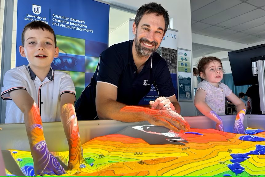
What first led you to this research area? I first was led into the world of immersive analytics through connections with the Australian Research Centre for Interactive and Virtual Environments at the University of South Australia. I had previously worked along quite traditional lines in my discipline of Earth Sciences, however, UniSA made an organisational change to create a combined faculty for STEM and I found myself surrounded by people with skills in handling and visualising different types of data in computer science, in software engineering, and in information technology. Through conversations we found alignments in their data visualisation technology and my traditional science background, and they needed good case studies to test and implement their tools. This was an opportunity to share my data and start thinking about the ways that we could tailor a platform to better suit my needs and my purposes, and those of the discipline that I represented. Bringing together those multidisciplinary perspectives started development of our own platforms, tools and techniques for dealing with data sets that are quite common amongst the physical sciences.
How do you see immersive technology impacting environmental/water research? Earth science uses complex spatial information layered with detailed in situ chemical information or physical information, and the immersive platforms are good for bringing different data sets together and bridging different scales. For environment or water research, you may want to look at specific impacts in the environment across entire catchments, or even continents, but also down to a very local context. This is extremely difficult without the right tools. However, in an immersive environment you can very naturally and seamlessly zoom all the way out to the entire catchment and all the way down to a single local environment through layering multivariable information; spatial layers, point information, historical data. Creating a comprehensive suite of data presented in an easy way. Immersive environments bring it all to one integrated platform, which is a significant advantage for water research.
Are there any limits of immersive technology? There are many ways of interacting with AR/VR, however there is often a learning curve to be comfortable using the tools, for example, a VR headset. With VR we can offer multiple ways to access virtual environments in multimodal platforms i.e. using a screen, headsets or both. However, VR has a hardware requirement, such as a high spec PC and headsets which can be very expensive.
There is an increasing trend in using and developing devices for these platforms by major brands (such as META and Apple), and as VR headsets and ‘smart glasses’ become increasingly common consumer products it will reduce the price barrier. The younger generation are digital natives, and using VR will become second nature to them. Shifting the way we access information, the devices we use and interacting with each other in a compelling way in a virtual environment will become the expectation rather than the exception.
In your opinion, what are the advantages and disadvantages of using AR/VR as a public engagement tool? All of us have an augmented reality device in our pockets, many of us use AR or VR daily on our mobile phone for google maps, online shopping, scanning and interpreting foreign language signs, weather forecasting, Pokémon go! These are examples of AR which have filtered into our day-to-day without us realising. Mobile devices are a great augmented reality tool to bring rich scientific information to the public. With regards to environmental research, we can create historical reconstructions or view of a natural landscape, say in flood or drought, which we can view through a mobile device. We can design a platform which people can take home for continued learning and sharing, in essence providing on demand learning.
What makes you excited about the use of VR/AR in science and education in the future? Immersive technologies are collaborative environments, they can bring people from across the globe into a single experience to explore together. It has the ability to connect experts, policy makers, industry from across the globe, bringing individuals and groups into a single virtual environment for a rich and informed conversation on an environmental topic. It creates a shared experience that is not limited by age, time limits or the accessibility for those who may not be able to travel.