Research program to inform water security in the Lower Limestone Coast
The Limestone Coast (LC) Landscape Board, South Eastern Water Conservation and Drainage Board and Goyder Institute for Water Research are partnering to deliver a research project to support water security in the Lower Limestone Coast.
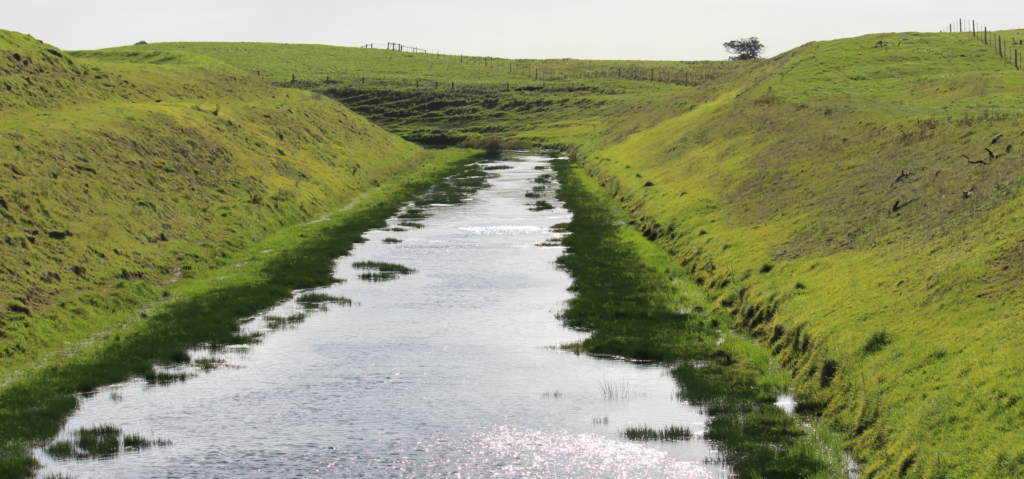
The Limestone Coast of South Australia is a highly modified landscape with an extensive cross-catchment drainage system converting what was once a wetland dominated landscape into one dominated by agricultural production. The region now has a diverse agricultural sector and extensive forestry plantations which are highly dependent on reliable rainfall and easy access to the region’s substantial groundwater resources. As climatic conditions are predicted to be drier and hotter it’s important to understand the impact on groundwater resources and consequent risks to primary production and the environment.
“As our climate dries and our water resources are increasingly contested, we need new knowledge to understand what is actually possible to build a water secure future,” said Dr Penny Schulz, Chair of the Limestone Coast Landscape Board.
The research project is delivering new knowledge on opportunities to manage water in the region. These include understanding water availability and addressing risks to primary industries and wetlands in a drying climate. Research teams from the CSIRO, Flinders University and the University of South Australia are delivering the work in five separate but inter-connected tasks:
- Quantifying the value of different water uses Dr Bethany Cooper from the University of South Australia is leading a team focussed on quantifying the value of consumptive and non-consumptive uses of water. Using historical data and future projections the residual value of water for dairy, hardwood and softwood plantations, viticulture and potatoes is modelled and expressed as a range and distribution. For non-consumptive values Bool Lagoon, a Ramsar listed wetland of international significance, is being used as a basis for a choice experiment. This technique provides an estimation of value by asking respondents their willingness to pay for a change in environmental condition. By presenting a limited number of choices of varying environmental attributes it is possible to statistically estimate how respondents trade off some attributes over others.
- Current and future water availability CSIRO researchers, led by Dr Matt Gibbs, are developing a water balance model for the region using the Bureau of Meteorology’s Australian Water Resources Assessment – Landscape (AWRA-L) model. The AWRA-L model is used operationally by the Bureau of Meteorology as part of the Australian Water Outlook and is the standard model applied for regional water resource assessments. Using the model, the team has brought together a range of national and regional datasets that concurrently capture runoff, recharge and soil moisture and incorporates seasonal dynamics as well as the variability across the Limestone Coast. This will allow for an analysis of the impact of contemporary climate projections for the complete water balance across the Limestone Coast region, informing both short and long-term management decisions.
- Wetland modelling At Flinders University Professor Adrian Werner’s team have been developing site specific models to represent three-dimensional aquifer-wetland interactions for two key groundwater dependent sites. The Lake Package is being used with MODFLOW6 to model water levels in Bool Lagoon and at the LC Landscape Board’s karst spring restoration property near Port MacDonnell. The model will test the feasibility of different options to change the water distribution in the local landscape to improve ecosystem health. Possible management actions to be tested include: redirecting or holding water back in drains, managed aquifer recharge, restricting groundwater extraction, reducing the extent of the wetland basin with levees and directly pumping water into the wetlands.
- Saltwater intrusion risk The coastal area south of Mount Gambier is an area of high value irrigated agriculture and significant karst springs where the risk of seawater intrusion is of concern for both irrigators and environmental assets. Dr Tim Munday, Research Director of CSIRO’s Deep Earth Imaging Future Science Platform, is leading the task to investigate the threat of seawater intrusion and potential changes under future conditions. An airborne electromagnetic survey of the area was undertaken in October 2022. The team have since been working on inverting, cleaning and refining a comprehensive data set. Initial results indicate that the interface is complex and the extent of intrusion is variable. Professor Adrian Werner’s Flinders University team is building on this work developing cross-sectional models, derived from a regional groundwater model, to model seawater intrusion.
- Landscape feasibility analysis GIS tool The final task, led by Professor Adrian Werner of Flinders University, is a collaborative effort between CSIRO and Flinders University researchers. It brings together information from a range of sources, including the other project tasks, in a dynamic GIS tool. This will allow the LC Landscape Board and partner agencies to view, compare and interrogate a diversity of hydrological and ecological information to inform policy and management decisions.
The research is timely with the Limestone Coast experiencing one of its driest seasons on record. Water licensees in the region are seeking certainty of water access and dependent ecosystems are under pressure.
The research outcomes will help to understand the risks to primary producers and water dependent ecosystems. They will also enable the LC Landscape Board and partner agencies to explore policy and management options to better manage the water resources of the region, such as the water in the drainage network, for the benefit of the environment and water users.
“The research project will provide an opportunity for us to explore the critical knowledge we must have to make the right decisions for our water future,” said Dr Schulz.
“The Goyder Institute for Water Research focuses on the delivery of research to support policy and on ground action. With the lower Limestone Coast such an important part of South Australia’s primary production base we are pleased to be able to partner and bring expertise from different institutions together to deliver this important work.” said Dr Alec Rolston, Director of the Goyder Institute for Water Research.
Together, the work will build tools to support future decision making to manage available water in a changing climate to support water security in the Limestone Coast. The project is expected to be completed in mid-2025.


