A new project from Goyder Institute scientists, funded by the South Australian Government, aims to better understand the interactions and impact of resource and infrastructure development on water and ecosystems in the Braemar, Stuart Shelf and Northern Eyre regions of South Australia.
The Stuart Shelf is part of the Adelaide Superbasin on the east of the Gawler Craton. The Braemar Province is located in eastern South Australia, roughly 210 km north of Adelaide; while the Northern Eyre region is defined as a northern strip of the Eyre Peninsula.
These 3 regions have various potential to develop mining, renewable energy, agriculture and tourism; however, each region faces the same restriction in access to water. The Braemar Province and Stuart Shelf region have high concentrations of known mineral resources, dominated by magnetite and iron oxide-copper-gold deposits respectively. Both of these areas are of high interest to develop new mining opportunities.
The regions have virtually no permanent surface water features and limited availability of fresh groundwater and each region supports important ecosystems, which are sensitive to variations in groundwater levels. Mining is a water intensive practice so it is important to understand, with limited access to groundwater, what could be the potential impact(s) on the environment.
Lead researcher, Dr Luk Peeters at CSIRO, and researchers at Flinders University will develop ecohydrological conceptual models to visualize connections between water flow and the environment. The models will combine information on hydrological (surface water and groundwater) components with ecological ones (e.g. specific taxa, communities and ecosystems) to understand their interactions.
The research team will go on to develop Impact Pathway Diagrams to understand and communicate how resource development (e.g. mining or renewable energy generation) can affect water resources, important species and the protected landscape. The methods uesed will provide the template for all future resource and renewable energy development across the state. It is important to understand how land use can be sustainably developed in these regions. This can then be used to ensure adverse impacts on water resources and the environment are avoided, minimised or mitigated.
Funding for this project has been provided by South Australian Government’s Department for Environment and Water, in partnership with the Department for Energy and Mining, to support this important project. It is also being supported by Landscape SA providing knowledge and expertise of the local regions. The project results will inform government on potential environmental impacts when evaluating an industry development proposal, and support companies to sustainably plan their development in the region.
For any further information, please contact Dr Bryony Cotterell, Goyder Institute Research Program Manager.
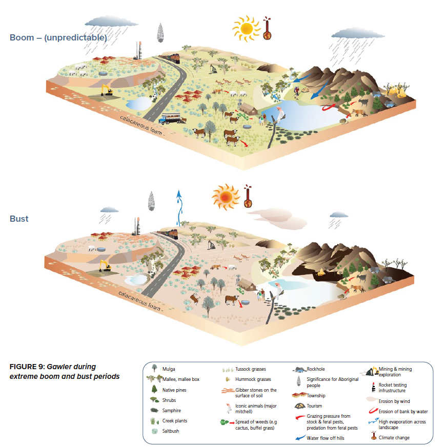
Note: Image is a landscape conceptual model for Gawler bioregion during extreme boom and bust periods (coincides with Stuart Shelf region) (after SA Arid Lands, 2022).