Water is scarce in outback areas and yet essential to help communities survive as well as increase opportunities for investment in remote regions. With water scarcity expected to become more apparent in the future, new, sustainable water sources will be required. New research released from the Goyder Institute for Water Research has identified a new outback water source and developed new techniques to map and target water resources that can be applied in remote areas across Australia and throughout the world.
A series of research reports have now been released as part of the Institute’s Facilitating Long-term Outback Water Solutions (G-Flows) Stage 3 project. This builds on two earlier stages of the G-Flows program, a collaboration between CSIRO, Flinders University and the South Australian Department for Environment and Water (DEW) that was initiated in 2011. The research program has brought together a team of over 20 staff with expertise in hydrogeology, hydrology, geophysics, groundwater modelling, spatial analysis and programming.
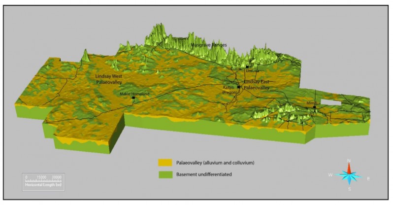
The first two stages of G-Flows (completed by 2015) developed and applied new and innovative geophysical techniques in various parts of South Australia, including the Musgrave Province, the north-east and north-west Gawler Craton, parts of the Frome Embayment in the east and the northern Eyre Peninsula. The third stage (2017-2020) has focused on groundwater in the Anangu Pitjantjatjara Yankunytjatjara (APY) Lands and the role that large buried palaeovalley systems can play as potential groundwater resources for community and enterprises. Palaeovalleys are ancient, buried river valleys formed when climatic conditions were different, and wetter, than they are today. Although they are not active on the surface they can form good quality aquifers and store groundwater.
The team identified and mapped several groundwater resources and developed a range of tools and techniques that can be used to assess the potential for suitable groundwater resources in any remote, arid and data poor regions. The final summary report of the G-Flows Stage-3 project outlines the work undertaken to:
- map palaeovalley locations with significantly improved accuracy across the APY Lands
- use multiple lines of evidence to investigate palaeovalley evolution, aquifer character and palaeovalley architecture, groundwater chemistry, recharge and flow.
This research will help reduce the significant risks faced when water development proposals are being considered in remote areas and allow for more informed decision-making for sustainable water supplies. It will also reduce project assessment times, contributing substantially to economic outcomes in South Australia, and ensure that economically-viable mining developments are not impeded by a lack of information on suitable water sources.
Key findings
An ancient palaeovalley was discovered and yielded water in a remote part of the APY Lands located in north western South Australia.
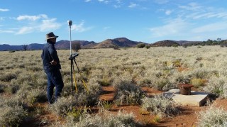
Wells were drilled in the targeted palaeovalley and they showed relatively high yields and low salinity groundwater (<1000 mg/L). The water-bearing formation is buried under tens of meters of ancient sediments and was located using a geophysical model of the area developed from airborne electromagnetic (AEM) survey data.
Drill and borehole data was used to confirm the AEM data , which was then used to develop a 3D geological model of the Musgrave Province in the APY Lands.
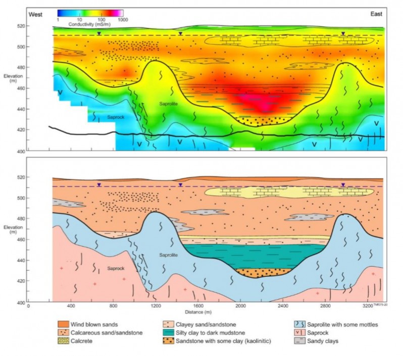
Water chemistry, environmental tracer analyses, and groundwater modelling were undertaken to better understand the rate of groundwater recharge and the movement of water through the landscape. Drilling identified at least three groundwater aquifers; a shallow phreatic water-table of calcareous mixed sand plain deposits; an interlayered coarse-grained sandstone and clay horizon and a very fine to coarse grained residual sand; and a saprolite/fractured rock aquifer that underlays the palaeovalley sedimentary rocks. While data is preliminary, the coarse-grained sandstones shows promise as a productive aquifer, with development yields varying between 5 and 20 L/s and salinities <1000 mg/L total dissolved solids (TDS).
Groundwater recharge was estimated to be between 2–20 mm/year on the ranges and between 0.5 and 10 mm/year on the alluvial plains. Groundwater flow and age modelling were undertaken to test different plausible conceptual models of the groundwater regime within the palaeovalley to aid the understanding of the available groundwater resource. Groundwater ages in the upper part of the valley-fill sequences were ~900 years, but over 8500 years in the deeper parts of the palaeovalleys.
The team also developed the Groundwater Knowledge Integration System (GKIS), a framework for groundwater prospectivity mapping, to help target drilling locations for future groundwater resource investigations in remote areas elsewhere. The GKIS can be updated as new information becomes available and can be used to extrapolate across data poor areas.
With a full toolkit of proven techniques and the GKIS groundwater prospectivity mapping resource, the G-Flows program has benefits far beyond the study site. The AEM geophysical interpretation techniques developed in stage 1 of the program have already been used by DEW to identify more secure groundwater supplies for a number of Aboriginal communities in the Musgrave Province in the APY Lands. The G-Flows Stage 3 project has built on this with additional information and interpretation so that these techniques will not only help to locate and characterise groundwater sources in the APY Lands – they can be used to search for deep groundwater resources in other remote landscapes across Australia and internationally.
Contact Neil Power (DEW) or Tim Munday (CSIRO) for more information about the program or Institute Director Dr Kane Aldridge to discuss our collaborative research programs.