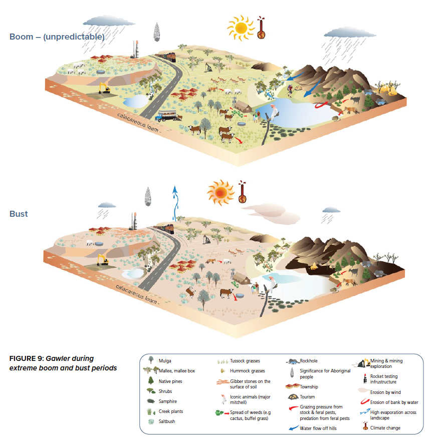
Conceptual ecohydrological models
A conceptual ecohydrological model describes how the landscape works and what the role of water in the landscape is. We developed cartoon-style block diagrams for the Braemar, Stuart Shelf and Northern Eyre region, in which we integrated information on geology, hydrology, ecology, landuse and infrastructure. Each of these graphics includes a table summarising the key features.
For each region we also created a factsheet describing the current and expected resource development, the current climate and trends in climate. The main ecohydrological features in the landscape, such as springs, lakes and watercourses are discussed in individual factsheets.
Impact pathway diagrams
The project team systematically identified all the activities associated with different approaches to mining (open pit, underground and in-situ recovery) and different stages of mining (exploration, production, post-mining). Those activities can be sources of stress on water and the environment. For instance, lowering the water table in the mine pit can lead to groundwater drawdown. These stressors are then linked to the receptors, the aspects of the environment we care about, such as springs and water courses.
We bring all these causal relationships, from activities to receptors, together in a network of impact pathways. Such a network allows to comprehensively identify and investigate potential hazards associated with mineral resource development. Factsheets accompany the causal network and expand on the knowledge base for the causal relations and discuss materiality of a causal pathway (when does it matter?) and what can be done to mitigate the hazard.
Results
Find the compiled PDF report on this webpage and visit the CSIRO website below for the full dataset, report and factsheets.
Peeters, Luk; Holland, Kate; London, Angela; Pollino, Carmel; Shanafield, Margaret; Guan, Huade; Thomas, Haylee; Werner, Adrian; Solorzano-Rivas, Cristina; & Jazayeri, Amir (2024): Ecohydrological Conceptual Models and Impact Pathway Diagrams for the Braemar, Stuart Shelf and Northern Eyre. v2. CSIRO. Data Collection. https://doi.org/10.25919/g64s-9×54